As Hurricane Melissa rapidly intensifies into a historic Category 5 storm, Jamaica and the Caribbean brace for its unprecedented impact. With life-threatening winds and torrential rains approaching, immediate preparedness is crucial. This blog provides the latest forecasts, safety guidelines, and expert advice to help you stay informed and protect yourself and your loved ones. Don’t delay—read on to learn how to prepare effectively, and share this vital information to keep communities safe and resilient.
Introduction
A Storm Rewriting History
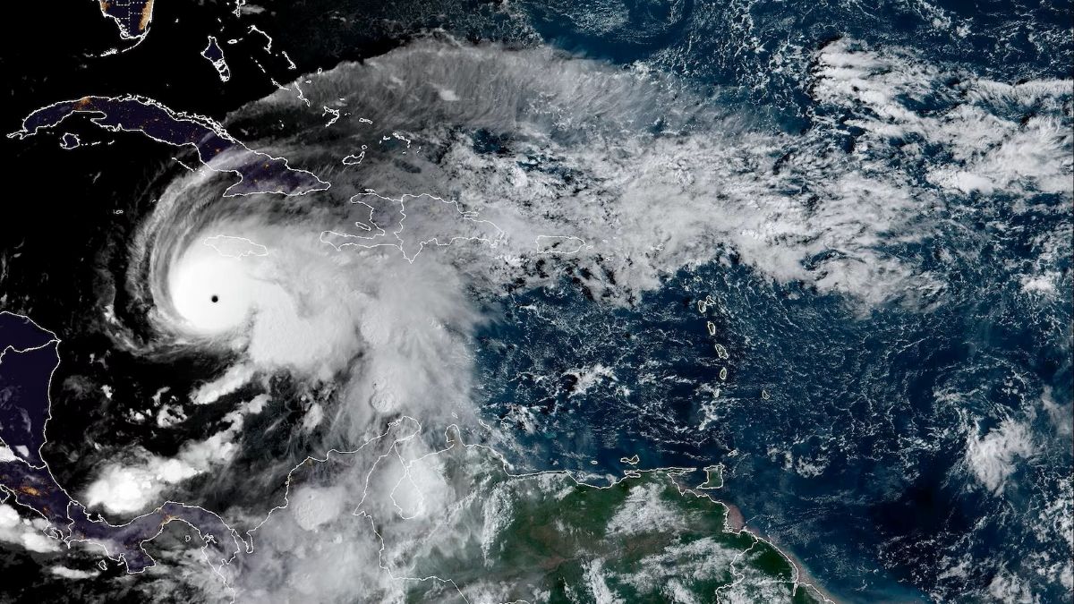
Hurricane Melissa is fast becoming one of the most powerful and historic storms to impact the Atlantic region. Barrelling towards Jamaica and the wider Caribbean as a fierce Category 5 hurricane, Melissa threatens to surpass all previous storms in strength and impact on the island.
Jamaica on High Alert
Jamaica is already grappling with government-ordered evacuations and urgent efforts to prepare for what could be the strongest hurricane in its recorded history. As of Monday, Melissa is dangerously close—only about 100 miles south of Jamaica’s main coast—bringing heavy rain bands and tropical storm conditions that are only expected to worsen in the next 24 hours.
The Added Danger of a Slow-Moving Storm
What makes Melissa especially threatening is its slow pace, creeping at just 5 mph over the sea. This prolongs the storm’s powerful winds, heavy rainfall, and coastal surges, intensifying the risk of catastrophic flooding, landslides, and widespread destruction, particularly in the hilly and coastal areas of Jamaica.
Regional Impact and Urgent Preparedness
The projected path stretches beyond Jamaica to include Haiti and the Bahamas, putting the entire region on emergency footing. Airports are closed, shelters are filling rapidly, and flooding and wind damage are already affecting vulnerable communities. Experts caution that Melissa’s intensity far exceeds past hurricanes like Gilbert in 1988.
Take Action Now
If you are in Jamaica or nearby in the Caribbean, the time to act is now. Seek shelter immediately, complete all necessary preparations, and avoid unnecessary travel. Stay updated through official sources such as the National Hurricane Center and Jamaican authorities. Share verified information with family and friends to ensure all communities remain safe during this historic and devastating storm.
Current Status and Meteorological Overview
Hurricane Melissa Reaches Category 5 Strength
Hurricane Melissa has intensified into a rare Category 5 storm, boasting sustained winds exceeding 165 mph. This marks it as one of the most powerful hurricanes of the 2025 season, raising concerns for catastrophic damage in its projected path.
Real-Time Tracking and Projected Path
According to updates from the National Hurricane Center and NOAA, Melissa’s eye is currently positioned about 100 miles south of Kingston, Jamaica. The storm is moving northwest slowly at around 5-7 mph, which allows its destructive forces to linger over vulnerable areas. Spaghetti model forecasts from multiple meteorological agencies consistently indicate a path directly impacting Jamaica, with a subsequent trajectory toward Cuba, Haiti, and the Bahamas.
Importance of Monitoring Official Trackers
Residents and officials are urged to follow continuously updated storm trackers provided by credible sources like the Weather Channel and NOAA. These tools display the hurricane’s current location, forecasted path, wind speeds, and alert levels — essential information for timely decision-making and safety planning.
What Residents Should Expect
Meteorologists warn that Jamaica faces a historic and dangerous event with prolonged exposure to winds, heavy rains, and flooding due to Melissa’s slow pace. Authorities emphasize urgent preparations and adherence to safety advisories as landfall nears.
Formation and Development
Origins in the Atlantic
Hurricane Melissa began as a tropical wave monitored by the National Hurricane Center in mid-October 2025. This tropical wave originated off the coast of West Africa and made its way across the Atlantic, passing through the Windward Islands before entering the Caribbean Sea. Its journey was marked by erratic movement due to weak steering winds and moderate wind shear, which initially slowed its development.
Rapid Intensification
Once Melissa reached the warm waters of the central Caribbean, environmental conditions changed dramatically. Wind shear in the region began to drop, allowing for deep convection and a better-organized storm structure. By October 25th, Melissa underwent rapid intensification, transforming from a tropical storm to a major hurricane in just 24 hours—a process driven by several meteorological triggers. Such rapid intensification, defined as an increase in wind speed of 35 mph or more within 24 hours, is rare but becoming more common as oceans warm.
Meteorological Triggers Behind Intensification
- Sea Temperature: Melissa’s explosive growth was powered by unusually warm ocean waters in the Caribbean, with surface temperatures up to 2.5°F (1.4°C) above average. Warm seas provide abundant energy for cyclones to strengthen, and in this case, are linked to climate shifts making such rapid intensification more frequent.
- Wind Shear: The reduction of disruptive upper-level winds allowed Melissa’s central core to become vertically aligned, fostering intensification. When wind shear decreases, tropical storms can quickly organize and become hurricanes.
- Weather Patterns: Favorable atmospheric conditions—such as ample moisture, weak steering currents, and low-pressure zones—contributed to Melissa slowing down and gaining strength. The storm’s slow pace increased the rainfall threat, as it lingered over the region longer, dumping historic amounts of water and amplifying risks for flooding and landslides.
Significance of This Development
Melissa is now the third Category 5 hurricane of the 2025 Atlantic season and has achieved this status due to the combination of extremely warm ocean waters and conducive weather patterns spanning several days. The rapid intensification seen here is a clear sign of evolving hurricane dynamics in the Atlantic, with climate change playing a notable role.
Hurricane Melissa’s Track and Projected Path
Real-Time Path and Tracker Information
As Hurricane Melissa pushes northward, live tracking maps from the National Hurricane Center and weather platforms offer a clear visualization of its projected journey. Currently, Melissa is positioned less than 130 miles south of Kingston, Jamaica, and is inching its way northwest at a painfully slow pace of 5 mph. This sluggish movement amplifies the danger, keeping towns and cities exposed to severe wind, storm surge, and relentless rain for extended periods.
Forecasters agree that Jamaica will bear the storm’s brunt between late Monday and Tuesday morning, with the eye expected to cross the island’s southern coast and exit through the north coast by Tuesday afternoon. After Jamaica, Melissa will likely take a northeast turn—sweeping across southeastern Cuba Tuesday night and the southeastern Bahamas on Wednesday. Meteorological ensemble models (spaghetti models) consistently plot this path while also highlighting a possible track near Bermuda by Thursday night.
Regional Impact Zones: Who Is at Risk?
- Jamaica: Mandatory evacuations are underway for vulnerable communities, especially on low-lying coasts and flood-prone areas in Kingston and St Catherine. Over 900 shelters have been activated, and both international airports are closed to ensure safety.
- Cuba: Eastern provinces, including Granma, Guantánamo, Santiago de Cuba, and Holguin, are facing hurricane warnings and tropical storm watches. Local officials are urging prompt evacuations, especially in coastal and river communities.
- Haiti and Bahamas: Southern Haiti and the Bahamas will see heavy rainfall, wind, and flooding as Melissa’s outer bands sweep across these regions through midweek. Tropical storm watches and warnings are in effect, and disaster agencies are actively preparing for impacts.
- Florida and USA East Coast: While spaghetti models show a low chance of direct landfall, forecasters warn that Melissa’s outer rain bands could graze southern Florida. The risk to mainland USA remains minimal, but residents are advised to follow advisories for possible flooding and high surf through the end of the week.
Evacuation Routes and Preparation
Local governments have mapped out evacuation corridors throughout Jamaica, especially near coastal and flood-prone regions. Shelters across the island have been well-stocked with emergency supplies, and rescue agencies are on standby. Travelers should double-check road closures and follow real-time alerts provided by Jamaican authorities and international weather bureaus.
Forecast Updates: What to Expect Next
Meteorologists expect Melissa to remain a powerful hurricane as it moves over Jamaica, Cuba, and the Bahamas. The combination of slow movement and massive rainfall means flooding and landslides could be catastrophic. Monitor trackers from the National Hurricane Center and the Weather Channel for up-to-the-minute changes in intensity and path forecasts.
Jamaica Prepares: Official Response and Community Actions
Government Actions and Emergency Measures
In response to Hurricane Melissa’s catastrophic approach, the Jamaican government has activated a full-scale emergency plan. Mandatory evacuations have been ordered for high-risk areas, especially coastal and flood-prone communities in and around Kingston, Clarendon, and St. Catherine. More than 650 emergency shelters across the island are now operational, providing refuge for displaced residents. Officials stress that no part of Jamaica is immune from the risk, urging all citizens to follow evacuation orders, stock emergency supplies, and seek official information from reliable sources.
Both Norman Manley International Airport in Kingston and Sangster International Airport in Montego Bay are closed indefinitely, stranding some travelers and suspending all incoming and outgoing flights. To facilitate movement and ensure quick evacuation and emergency response, toll roads on the island will remain open and, when conditions permit, operate free of charge.
Community and International Aid Response
Relief teams, including local agencies and international NGOs, have pre-positioned vital supplies—shelter kits, tarps, hygiene materials, and water—at schools, churches, and community centers throughout Jamaica. Volunteers and local leaders are helping residents, especially the vulnerable, to reach safety and prepare their homes as much as possible before the storm’s main impacts.
Residents report a strong sense of collective responsibility, with neighbors assisting one another in securing properties, gathering supplies, and evacuating the most at-risk individuals. Local officials are continually urging everyone to heed warnings, stressing that Hurricane Melissa is not a storm anyone can afford to underestimate, and that taking action is a matter of life and death.
Impact Forecast: What to Expect
Wind Speeds and Rainfall Predictions
Hurricane Melissa’s approach brings maximum sustained winds of 160 mph (260 km/h), with even higher gusts in elevated regions. As the storm intensifies, wind speeds could surpass 190 mph, especially during landfall on Jamaica’s southern coast. These winds are strong enough to tear roofs from buildings, topple large trees, and destroy poorly constructed homes.
Rainfall predictions are dire. Experts from the National Hurricane Center warn of 15 to 30 inches of rain across Jamaica, with some mountainous and eastern areas expecting up to 40 inches (over 1 meter) in just a few days. This volume far exceeds Jamaica’s normal annual rainfall and could cause historic flooding and landslides.
Storm Surges and Flood Risks
Storm surges of 9 to 13 feet are likely along Jamaica’s southern and northeastern coastlines. These surges can inundate coastal towns such as Port Royal, Old Harbour Bay, and Rocky Point, overwhelming beaches and infrastructure with waves and rising seawater. Flash flooding is a major concern in every parish, with the highest risk zones in Cornwall and Middlesex Counties.
Potential Impacts on Infrastructure, Utilities, and Travel
Melissa’s combined threats of extreme wind, heavy rain, and flooding will test the island’s infrastructure.
- Roads and highways may become impassable due to flooding and debris.
- Both Norman Manley and Sangster International Airports are shut down, impacting travel throughout the Caribbean region.
- Power and communications may be disrupted for days or weeks in many parishes.
- Tourism operations are suspended, with resorts evacuating guests and cruise lines rerouting ships.
Safety Advisories and Emergency Notifications
Authorities and meteorologists stress that everyone in Jamaica should shelter in place, avoid unnecessary travel, and follow government instructions.
- Mandatory evacuation orders remain in effect for low-lying, coastal, and flood-prone communities.
- Emergency shelters are open and stocked with essential supplies across the island.
- Residents should keep tuned to official updates from the National Hurricane Center, Jamaica Meteorological Service, and local disaster management offices for continuous alerts and guidance.
Every citizen, traveler, and visitor should understand that Melissa poses a life-threatening danger, and that safety actions must be prompt and coordinated as the storm’s impacts unfold.
How to Track Hurricanes: Tools and Models
Tracking and Forecasting Methods
Meteorologists use a combination of advanced models and real-time data to track hurricanes and predict their paths. Among the most widely recognized tools are “spaghetti models,” which display many possible tracks of a storm based on different computer simulations and assumptions. Each line represents a separate model’s forecast, making the map look like a tangled plate of spaghetti and showing a range of possible future positions for the hurricane.
Spaghetti models are valued for highlighting areas of uncertainty in a storm’s trajectory. If many lines cluster closely together, forecasters have high confidence in the forecast path. Wide divergence means less certainty and a broader area of risk. These models are complemented by “forecast cones,” produced by agencies like the National Hurricane Center (NHC), which indicate probable paths and spread of impact based on ensemble data.
Recommended Tools for Tracking
- National Hurricane Center (NHC): The NHC issues official advisories, forecast maps, tracks, and discussion posts that synthesize the best data from multiple model runs. Their website offers up-to-date information on hurricane intensity, path, and alerts.
- Weather Channel: A popular source for real-time updates, expert insights, and interactive trackers showing the storm’s current position, wind field, and predicted changes.
- Track The Tropics: This site provides live spaghetti model updates, interactive trajectory maps, and model convergence analysis for ongoing storms—including Hurricane Melissa.
- Wunderground and Yahoo Weather: These platforms also deliver user-friendly tracking maps, intensity forecasts, and storm surge predictions for public use.
The Weather Channel offers comprehensive live trackers and detailed storm forecasts, available at this link.
Why Multiple Models Matter
Spaghetti models, forecast cones, ensemble tracks, and intensity predictors work together to give the public the clearest possible picture of a hurricane’s potential behavior. No single model is perfect, but comparing several lines of forecast data helps emergency managers, residents, and travelers plan accordingly. These tools, when paired with local advisories, are essential for making informed decisions about evacuation, safety, and travel as storms like Melissa approach.
Lessons from Past Hurricanes
Historical Context and Previous Storms
Jamaica is no stranger to hurricanes, with many storms passing near or over the island in recent decades. However, according to the National Hurricane Center’s records, the island has never experienced a direct landfall from a Category 4 or 5 hurricane until Hurricane Melissa. Historically, Jamaica’s strongest storms were Category 3 hurricanes—most notably Hurricane Gilbert in 1988, which devastated the nation with wind gusts of 130 mph, causing $700 million in damages and claiming at least 45 lives. Hurricane Charlie in 1951 brought massive flooding with 17 inches of rain in Kingston, marking Jamaica’s deadliest natural disaster of the 20th century.
Comparing Hurricane Melissa with Gilbert, experts now warn that Melissa’s sustained wind speeds and rainfall totals far exceed those of previous storms. Melissa brings 160 mph winds, possibly up to 40 inches of rain—more than the typical annual rainfall for some areas—along with towering storm surges and prolonged exposure due to the storm’s slow movement.
Lessons Learned and Improved Preparedness
After Hurricane Gilbert, authorities improved early warning systems, strengthened building codes, advanced evacuation planning, and invested in community education about disaster risks. Organizations such as ODPEM (Office of Disaster Preparedness and Emergency Management) routinely conduct drills, stockpile emergency supplies, and prepare designated shelters in anticipation of major storms.
Jamaica’s resilience can be seen in its coordinated government action, widespread community involvement, and faith in planning and preparedness. These measures have helped reduce loss of life in subsequent hurricanes, but experts still urge vigilance and adherence to emergency protocols, especially in the face of an unprecedented storm like Melissa.
Warnings for the Future
Meteorologists and disaster management officials stress that every hurricane season brings new challenges. As climate change increases the risk of stronger, slower-moving storms, lessons from past hurricanes must guide current and future responses. Preparation, prompt evacuation, reliable information, and community solidarity remain the most effective ways to protect lives and property in Jamaica and throughout the Caribbean.
For a broader understanding of how natural disasters impact communities and the importance of preparedness, check out our detailed article on Kamchatka Earthquake and Tsunami 2025: What You Should Know. It highlights essential lessons on disaster response and community resilience that are applicable worldwide.
Safety and Preparedness Guide
Preparing Emergency Kits
Before Hurricane Melissa arrives, every household should assemble an emergency kit that includes:
- At least three days’ supply of water (one gallon per person, per day) and non-perishable food
- Battery-powered or hand-crank radio and extra batteries to stay updated with official alerts
- Flashlights, candles, and matches
- First aid kit and necessary medicines
- Important documents like IDs, insurance papers, bank info in waterproof containers
- Personal hygiene items and face masks
- Portable phone chargers or power banks
- Cash in small bills and change for emergencies
- Clothes, sturdy shoes, blankets, and rain gear
Evacuation Planning
Residents in high-risk zones must plan evacuation routes ahead of time. Know the locations of nearest official shelters, and if advised, evacuate early to avoid traffic and hazardous conditions. Stay in contact with local authorities and community leaders who will provide evacuation instructions and updates.
Staying Informed
Continuous monitoring of official hurricane updates is crucial. Follow trusted sources such as:
- National Hurricane Center (NHC)
- Jamaica Meteorological Service
- Office of Disaster Preparedness and Emergency Management (ODPEM)
- Local news outlets and radio broadcasts
- Weather Channel and trusted weather apps like MyRadar and AccuWeather
Keep your devices charged and ready to receive alerts. Avoid relying on social media rumors; instead, verify all information with official sources to prevent misinformation.
Essential Contacts and Resources
- ODPEM Emergency Hotline: 888
- Jamaica Fire Brigade: 110 or 119
- Jamaica Constabulary Force: 119 or 110
- National Emergency Management Center
- Local parish council offices
Community centers and many schools serve as official shelters. If you need assistance or shelter, contact local authorities immediately.
By following this guide, residents and visitors in Jamaica can enhance their safety and preparedness during Hurricane Melissa, reducing risks and improving resilience throughout the storm’s passage.
Conclusion
Hurricane Melissa is a historic and life-threatening storm that demands our full attention and urgent action. As it closes in on Jamaica and the wider Caribbean, every resident, visitor, and authority must stay vigilant and prioritize safety above all else. It is critical to monitor only authentic and reliable sources such as the National Hurricane Center, Jamaica Meteorological Service, and official government emergency channels for up-to-the-minute updates.
Sharing verified information within your communities and social networks can save lives. Encourage friends, family, and neighbors to prepare early, follow evacuation orders, and use emergency shelters if needed. Your proactive efforts can empower others and ensure collective safety during this unprecedented event.
Please share this blog and official updates widely on social media platforms and messaging apps to amplify the reach of crucial warnings and safety information. Together, let’s help Jamaica and the Caribbean brace for Hurricane Melissa with knowledge, preparedness, and solidarity.
Stay safe. Stay informed. Act now.
FAQs About Hurricane Melissa
When will Hurricane Melissa hit Jamaica?
Hurricane Melissa is expected to make landfall on Jamaica’s southern coast between late Monday and early Tuesday morning. The storm’s slow movement means severe conditions will persist for an extended period, causing prolonged wind damage and flooding.
Is Melissa expected to reach Florida?
Current forecast models indicate a low probability of Melissa making direct landfall in Florida. However, outer rain bands and waves could affect parts of southern Florida and the Bahamas later in the week. Residents there should remain alert and monitor local weather updates for any changes.
How does a Category 5 hurricane affect communities?
Category 5 hurricanes have sustained winds exceeding 157 mph, capable of causing catastrophic damage. Communities can expect total roof failure on many homes, widespread power outages lasting weeks, major flooding, and destruction of infrastructure including roads and bridges. Emergency services often face challenges in rescue and restoration efforts for days after the storm clears.
What preparations should residents make now?
Residents should secure an emergency supply kit, plan evacuation routes, reinforce their homes if possible, and follow all evacuation orders from authorities. Staying informed through official sources and avoiding travel during the storm are critical for safety.
Where can I find real-time updates on Hurricane Melissa?
The National Hurricane Center (NHC), Jamaica Meteorological Service, and trusted news outlets like the Weather Channel provide continuous updates. Using reliable weather apps with notifications can help residents stay informed about changing conditions.
Enjoyed this article?
If you find the blogs helpful, you can support Chatterlane with a small contribution. Even a cup of coffee helps me continue creating useful, well-researched content.
Comments
One response to “Hurricane Melissa 2025: Jamaica’s Historic Category 5 Threat”
As soon as I detected this site I went on reddit to share some of the love with them.